

GARMIN |
Ref: 010-02347-11
Garmin GPS Navigator Montana 700i
Details
https://www.greenlandmx.eu/en/garmin-gps-navigator-montana-700i/010-02347-11.html
GARMIN |
Ref: 010-02347-11
Garmin GPS Navigator Montana 700i
Personalized
Customer Service
Pay less
Get more
Club GMX
Exclusive Discounts
MSRP
699.99€
|
You save
28€
GMX Price
-4%
671
,
99
€
VAT Included
With free shipping
Did you find it cheaper?


Description
Technical details
Ratings
Garmin GPS Navigator Montana 700i
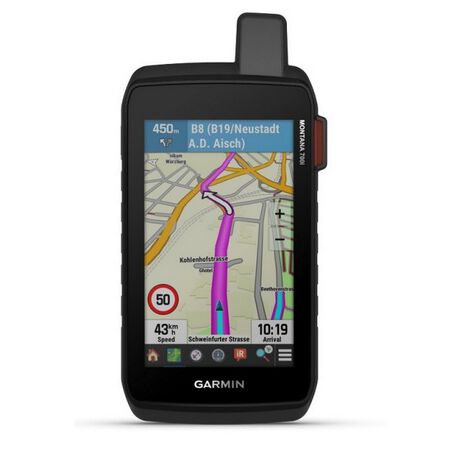
GO INTO THE WILD WITH A SATELLITE CONNECTION
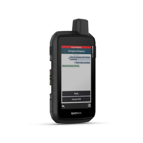
To keep adventurers in touch and on track, the Montana 700i handheld combines the flexibility of on- or off-road navigation with global messaging and interactive SOS via inReach satellite technology1.
- Big news. A full QWERTY keyboard lets you easily type messages.
- Wander wider and still stay in touch — with inReach for messaging and 24/7 SOS.
- Routable TopoActive Europe maps. Now you’re free to take it off-road or on.
- Meets MIL-STD 810 for thermal, shock, water and vibration.
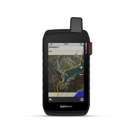
- Get a clear perspective of BirdsEye Satellite Imagery right to your device.
- Power your adventures with 18+ hours of lithium-ion battery life in GPS mode.
- TWO-WAY MESSAGING: Exchange text messages with loved ones, post to social media, or communicate via inReach device to inReach device in the field (active satellite subscription required).
- INTERACTIVE SOS: In case of emergency, trigger an interactive SOS message to GEOS, the Garmin-powered International Emergency Response Coordination Centre (IERCC) with professional 24/7 global monitoring and response center (active satellite subscription required).
- GLOBAL CONNECTIVITY: Instead of relying on mobile phone coverage, now your messages, SOS and tracking are transferred via the 100% global Iridium® satellite network (active satellite subscription required).
- INREACH WEATHER: Available inReach weather forecast service provides detailed updates directly to your Montana handheld or paired devices, so you’ll know what to expect en route.
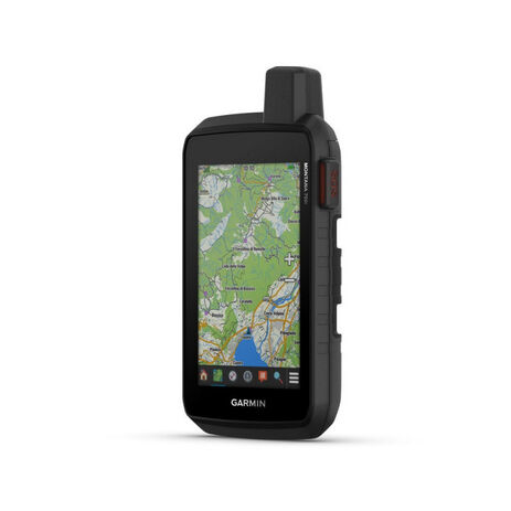
- RUGGED BY DESIGN: This durable, water-resistant handheld is tested to U.S. military standards and features a glove-friendly 5” touchscreen that’s 50% larger than previous Montana models.
- CITY NAVIGATOR MAPS: Seamlessly transition from trails to road navigation with preloaded City Navigator street mapping, which guides your drive with easy-to-follow turn-by-turn directions.
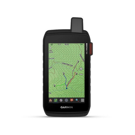
- TOPOACTIVE EUROPE MAPS: To navigate your adventures, use preloaded TopoActive Europe maps. View elevations, coastlines, rivers, landmarks, and more.
- SATELLITE VIEWS: Use direct-to-device downloads of Birdseye Satellite Imagery (no annual subscription required) to see photo-realistic views and create waypoints based on landmarks.
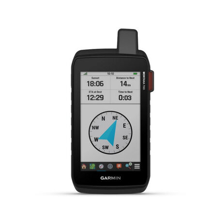
- ABC SENSORS: Navigate your next trail with ABC sensors, including an altimeter for elevation data, a barometer to monitor the weather and 3-axis electronic compass.
- ACTIVE WEATHER: Use cellular connectivity1 to access up-to-date Active Weather forecasts through the Garmin Connect app.
- DOG TRACKING: This Montana syncs with compatible Astro® or
- WIKILOC TRAILS: This preloaded app lets you easily download hiking, cycling and other Wikiloc trails shared by outdoor enthusiasts like you. Get a free 60-day Wikiloc Premium trial to try this and other exclusive features. Learn more.
General
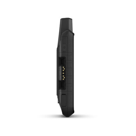
- Dimension 9.19 x 18.30 x 3.27 cm
- Touchscreen
- Display Size 6.48 x 10.80 cm; 5" diag (12.70 cm)
- Display Resolution 480 x 800 pixels
- Display Type WVGA transflective, dual orientation
- Weight 410 g with included lithium-ion battery pack
- Battery type rechargeable lithium-ion (included)
- Battery life GPS Mode: up to 18 hours
- Expedition Mode: up to 330 hours
- GPS Mode, 10 min Tracking: up to 18 hours
- Expedition Mode, 30 min Tracking: up to 300 hours
- Water rating IPX7
- MIL-STD-810 yes (thermal, shock, water, vibe)
- Interface High speed micro USB and NMEA 0183 compatible
- Memory/history 16 GB (user space varies based on included mapping)
Maps & memory
- Preloaded maps Yes (TopoActive Europe)
- Ability to add maps
- Basemap
- Automatic routing (turn by turn routing on roads) for outdoor activities
- Automatic routing (turn by turn routing on roads) for motorized vehicles
- Map segments 15000
- BirdsEye Yes (direct to device)
- Includes detailed hydrographic features (coastlines, lake/river shorelines, wetlands and perennial and seasonal streams)
- Includes searchable points of interests (parks, campgrounds, scenic lookouts and picnic sites)
- Displays national, state and local parks, forests, and wilderness areas
- Storage and Power Capacity Yes (32 GB max microSD™ card)
- Waypoints/favourites/locations 10000
- Tracks 250
- Navigation Track Log 20000 points, 250 saved gpx tracks, 300 saved fit activities
- Navigation Routes 250, 250 points per route; 50 points auto routing
- Rinex logging
- High-sensitivity receiver
- GPS
- Galileo
- Barometric altimeter
- Compass Yes (tilt-compensated 3-axis)
- GPS compass (while moving)
- Connect IQ™ (downloadable watch faces, data fields, widgets and apps)
- Smart notifications on handheld
- Weather
- VIRB® camera remote
- Compatible with Garmin Connect™ Mobile
- Active Weather
- LiveTrack
- Point-to-point navigation
- Area calculation
- Hunt/fish calendar
- Sun and moon information
- XERO™ Locations
- Geocaching-friendly yes (Geocache Live)
- Custom maps compatible yes (500 custom map tiles)
- Picture viewer
- LED beacon flashlight
- Interactive SOS
- Send and receive text messages to SMS and email
- Send and receive text messages to other inReach device
- Exchange locations with other inReach device
- MapShare compatible with tracking
- Virtual keyboard for custom messaging
- Send waypoints to MapShare during trip
- Send route selection to MapShare during trip
- inReach remote compatible
- Compatible with Garmin Explore™ app
- Garmin Explore website compatible
- Dog tracking Yes (when paired to compatible dog track system)
- Connections Wireless Connectivity Yes (Wi-Fi®, Bluetooth®, ANT+®)
Sensors
Daily smart features
Safety and tracking features
Outdoor recreation
inReach® features
Outdoor applications
Connections
| Brand | Garmin |
-
